An ATZ is a defined airspace located around an aerodrome.
The purpose of the ATZ is to protect aerodrome traffic, i.e., traffic in the maneuvering area and traffic in the vicinity of an aerodrome.
Unlike other types of airspace, the ATZ is the smallest.
Typically, it has a cylindrical shape that extends from the surface to a few thousand feet above the ground, with a radius of a few miles.
The airspace within an ATZ can be of two different types:
Controlled
There is a Control Tower at the aerodrome, and aircraft must comply with the instructions of the air traffic controller.
Uncontrolled
In this case, services such as Aerodrome Flight Information Service (AFIS) are provided within what would be called the FIZ or “Flight Information Zone.”
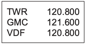
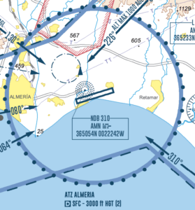
The best source for information on ATZ is undoubtedly the AIP (Aeronautical Information Publication) of each country. In the AIP, you can find visual flight charts (VAC) showing all airspace areas.
The first thing to look for is the text box where you will see the classification of airspace along with the vertical limits of the ATZ.
In the example in the image, we have:
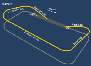
All aerodromes must have a defined circuit, and in the case of having an ATZ, the procedures indicated by the air traffic controller must be followed.
The main function of the circuit is to organize traffic at an aerodrome and establish procedures for the takeoff and landing of aircraft. The circuit is composed of five segments and four turns, as visualized in the image below. The way to differentiate which circuit procedure should be followed is through the designation of the runway in use and the direction of the turns to be made (right or left).
For example, in the image, you can see a left circuit for runway 03.
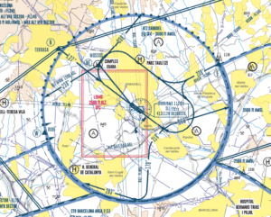
For an aircraft to enter or exit an ATZ, it must do so through established points. Additionally, when it is at these points, it must always communicate its position by radio. Similar to the described circuits, listening to radio transmissions is of great value for the situational awareness of drone pilots. It allows them to identify the position of aircraft within the ATZ at all times.
The image below shows the mandatory notification points N, E, and W (all marked with a blue circle) for an ATZ and the defined flight circuit: