News & Blog.

BLOG POSTS

CTRs and Drone Operations: What You Need to Know about Controlled Traffic Regions

Table of Contents

When we hear the word CTR in the world of drones, we directly associate it with “possible restrictions.” In this article, we will discover what a CTR is exactly and how to find its limits and characteristics.  

What is a CTR for drone use?

It is called a Control Zone, although the acronym CTR stands for “Control Traffic Region.” It is a volume of airspace that typically surrounds an airport, starting from the surface and extending to its defined vertical limits. This volume of airspace, as its name suggests, is of a controlled type, and its function is to protect the air traffic operating to and from the airport.


As it is considered controlled airspace, aircraft can only fly when they have received authorisation from air traffic control. This way, air traffic controllers know perfectly which aircraft are flying within the CTR and what their intentions are (arriving at the airport or departing from the area). They can also monitor the progress of the flight using equipment such as radar and transponders. 

CTR - EU Drone Port

Using Radio with Drones

In CTRs, it is mandatory to establish radio contact with the air traffic control facilities responsible for management. These are typically:

  • Control tower


  • Departures and arrivals (Approach)

Information about CTRs for drone flights

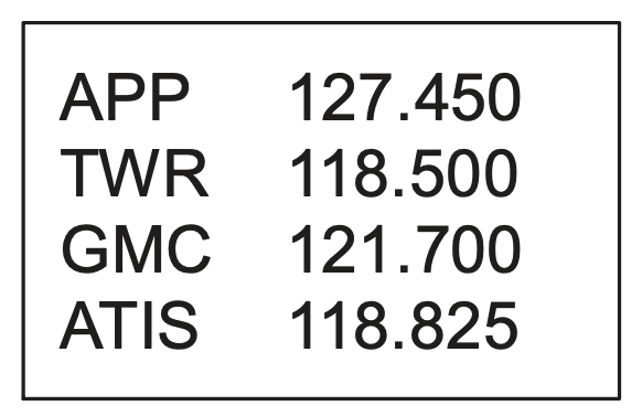
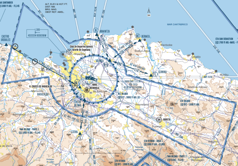
The best source of information we can find to access data about a CTR is undoubtedly the AIP (Aeronautical Information Publication) of each country. In the AIP, we can find visual flight charts (VAC) showing all the airspace in the flight areas.

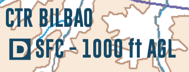
The first thing to look for is the text box where you will see the classification of the airspace along with the vertical limits of the CTR. In the example shown in the image, we have:
Information about CTRs for drone flights - EU Drone Port
  • Classification of Class D airspace


  • Lower vertical limit: surface


  • Upper vertical limit: 1000 feet above ground


Another crucial piece of information that can be found on VAC charts at the top is the box with the frequencies used in the airspace. In the example in the image below, we see that the approach frequency (APP) is 127.450 MHz.
Information about CTRs for drone flights - EU Drone Port

Finally, we are interested in knowing the horizontal dimensions of the CTR. This can be seen on the VAC chart, as shown below. 

Information about CTRs for drone flights - EU Drone Port

But if you want to know the exact points of the airspace volume’s geometry, you should consult the “Aerodrome Data” document, where you will find each set of coordinates. Here’s an example: 

Information about CTRs for drone flights - EU Drone Port